Monday, February 29, 2016

The Great 20 Beautiful Scenary from Bangka Belitung

Bangka Belitung (Babel abbreviated) is a province in Indonesia, which consists of two major islands, the island of Bangka and Belitung islands and small islands such as LeparPongokand Mendanau Selat Nasik, total island which has been named amounted to 470 pieces and only 50 islands are inhabited. Bangka Belitung is located in the eastern part of the island of Sumatra, close to the South Sumatra province. Bangka Belitung is known as the producer of tin, has a beautiful beach and inter-ethnic harmony. The capital of the province is Pangkalpinang. Bangka Belitung province is very famous for its beaches travel. Some of them are as follows :

1. Pantai Tanjung Tinggi (Tanjung Tinggi Beach) 
Tanjung Tinggi beach is located on the island of Belitung and is 30 km from Tanjung Pandan, Belitung island's largest city. Its main characteristic is the presence of granite boulders on the shoreline great. Cape Coast High popularity skyrocketed after once used for location filming "Laskar Pelangi".


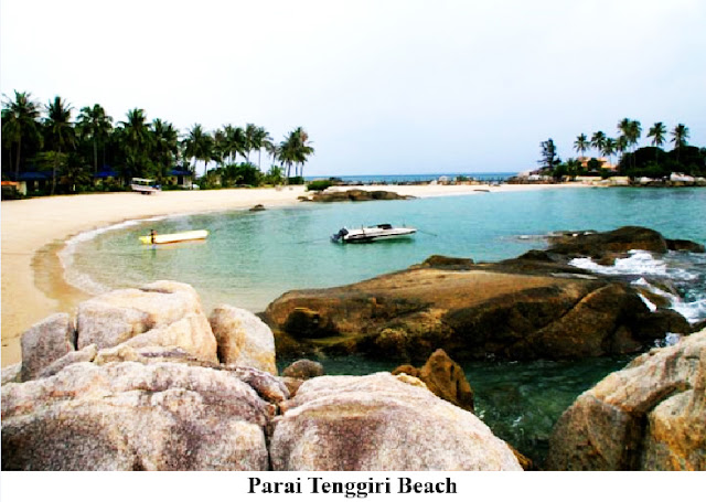
2.Pantai Parai Tenggiri (Parai Tenggiri Beach)
Parai Tenggiri Beach is located in the area, about 40 km from Depati Amir, Pangkalpinang. Sinar Baru Village, District Sungailiat, Bangka, Bangka Belitung province. This beach has a sloping contour with a relatively small waves. In Parai Tenggiri you can see granite boulders large variety of unique shapes that can not be found in other areas. This makes the rocks on this beach scenery becomes even more special.
Currently,  Parai Tenggiri Beach area designated as a green tourist area called Parai Green Resort with great concern the effort to save the environment by reducing the use of materials that can pollute beaches, such as plastic, as well as planting trees in this tourist location.


3. Pantai Bukit Batu (Bukit Batu Beach)
Bukit Batu East Belitung Beach, located in the village of Bird Bath Damar District of East Belitung adjoining the beach Bird Bath with a distance of approximately 2 km. This beach is located on the island of Belitung. On this beach there is often a nesting turtle, it is easy to detect when the turtles lay eggs, when the full moon of the season as well as the presence of lizards. The lizard, it will usually hunt the eggs laid by the mother turtles.


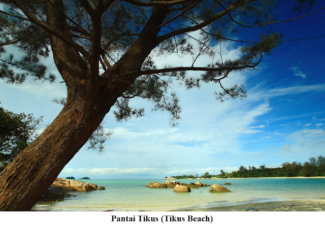
4. Pantai Tikus (Tikus Beach)
Tikus beach is located in Rebo Village, Kenanga Urban Village, District Sungailiat, Bangka, Bangka Island, Bangka Belitung province. Unspoiled beach area is adjacent to a hill called Bukit Rebo. The beach also has fine white sand and also various types of granite boulders.


5. Pantai Pulau Lengkuas (Lengkuas Island Beach)
Lengkuas Island is one of the excellent tourism in Bangka Belitung Province. This island is one of the hundreds of islands that surround the island of Belitung. The main attraction on the island is an old lighthouse built by the Dutch colonial government in 1882, the clarity of the sea is awesome.


6. Pulau Perawan tak Berpenghuni (Virgin Island)
Virgin Island is a small island in Belinyu that can be reached only with a time of 10 minutes by boat. To go to the Virgin Island of Pangkalpinang takes about 2 hours drive. The island is perfect for those who want to see a variety of hidden places that are still natural, because here arguably untouched by the development means. This location is perfect also for small group outing because we can do the exciting adventures in this location.
Virgin Island itself can be surrounded 360 degrees by foot through the obstacle granite, beach and sea, certainly intriguing. Here too there is a "Sofa Sand". Virgin Island, a beautiful uninhabited island.


7. Pantai Penyusuk (Penyusuk Beach)
Penyusuk beach is situated in the village of Penyusuk, Village Hill of word and is in the north of the city of Pangkalpinang with a distance of about 90 km. (Near Romodong). Penyusuk coast is dominated by granite and granite stone piles combined with the lush green of the trees that grow in the rocks.


8. Lubang Bekas Penggalian Timah (Tin Multiplication Holes)
Bangka Belitung famous as a producer of tin were excellent. in this place there are many former lake Excavation Timah. This is a photo "Hole Camoy" former Air Anyir extracting tin in  Sungai LiatBangka Belitung.


9. Tanjung Kelayang (Tanjung Kelayang Beach)
This beautiful beach is located about 27 KM north of Tanjung Pandan, Belitung. Still offers the beauty of granite boulders scattered in the sea, especially with the presence of stone Garuda unique iconic Cape Kelayang. Natural stone is very large in the middle of the sea very much resembles a bird's head.


10. Pantai Matras (Matras Beach)
The beach is quite unique because as divided into two zones. namely the northern zone which is the white sand and southern zones that form a beautiful cluster of rocks. The other name of this object is a beach paradise. The place is very worthy of the name of the alias, because it offers incomparable beauty. Matras is the longest white sand beach in Bangka Belitung. Its location adjacent to parai, about 40 KM from Pangkalpinang.


11. Pulau Memperak (Memperak Island)
Memperak Island is one of the unspoiled island that offers beautiful expanse of white sandy beach with a charming underwater conditions like paradise marine park. The island waters have the color of clear sea water so that the beauty of the coral reefs can be seen from the surface of the water.
Memperak island still included in the District of Manggar, East Belitung can be reached from the capital manggar with travel for 1.5 hours by boat motors. The waters of this island has a visibility of up to 15 meters making it easier for divers to perform diving activities. No wonder that, Memperak island became a favorite island for divers.


12. Pantai Teluk Uber (Teluk Uber Beach)
Teluk Uber Beach is one of the coastal tourism on the island of Bangka, precisely in the Village Rambak, Village Srimenanti, District Sungailiat, Bangka. The beach is about 40 km from the city of Pangkalpinang. The beach is so natural it has a total area of about 25 hectares with overhanging inland locations that form around the bay so that people call it the Teluk Uber, more precisely Teluk Uber Coast.
In light golden sandy beaches, there are a cluster of granite rocks which are on either side so that the waves coming to this beach to be small because it was blocked by the cluster of granite boulders. Contours sloping beach and the sea water is clean and clear and the small beach waves make the beach safe for swimming.


13.  Pantai Tanjung Kiras (Tanjung Kiras Beach)
Tanjung Kiras Beach is located behind the village of Tanjung Kandis forest area, Membalong, South Belitong. This beach looks so charming and exotic. Granite scenery and turquoise color of the sea is like being a wonderful blend in Tanjung Kiras Beach. Soft white sand and relatively calm surf beach that makes being at this beach provides an atmosphere of peace in the heart.


14. Pantai Penyabong (Penyabong Beach)
Penyabong is the name of the beach is in the area Membalong, Belitung the South. Membalong is the name of a district in the Southwest of the island of Belitung, where village Membalong is the name of the capital of the subdistrict. Penyabong beach is one of the tourist wealth of Belitung frequented local people on weekends. The beach is about 65 km from Tanjung Pandan. On average it took almost 2 hours drive


15.  Pantai Tanjung Pendam (Tanjung Pendam Beach)
Tanjung Pendam Beach are located in the subdistrict Sijuk, Belitung district. Tanjung Pendam Beach arguably still a virgin. Because until now the area beaches unspoiled by investors. Not far from the port of Tanjung Pendam, visitors will encounter the legacy of the tribe Sawang (sea tribes) 


16. Pantai Bukit Berahu (Bukit Berahu Beach)
Bukit Berahu Beach is located in the village of Tanjung Binga, Sijuk, Belitung. The beach is somewhat hidden in the foothills Berahu, which can be accessed by descending steps ramps numbering no less than 96 pieces. When viewed on a map, Bukit Berahu tilted toward the West, right towards the Eastern side of the island of Bangka, which is about 50 km if a straight line. Locations beaches located in the southern tip of a promontory that was about 1 km


17. Pantai Tanjung Pesona (Tanjung Pesona Beach)
Tanjung Pesona Beach located in the village of Creep, District Sungailiat. Located 9 km from the city Sungailiat Bangka district. The beach is located in the middle of nowhere between the Gulf Coast and beaches Uber Rat. This beach has a panoramic view of the open sea, on a promontory with a large array of exotic rocks.
Tanjung Pesona Beach has a beautiful view, especially when looking at the ocean. The sea is calm enough to swim. The charm of the beach offers a cool, distant sea breezes. Large trees are well groomed Attraction region Bangka charm make this one become obligatory destination for tourists who come to Bangka..


18. Pantai Gunung Namak (Gunung Namak Beach)
Gunung Namak Beach located in Toboali, district South Bangka, Bangka Island,   is still very beautiful uncontaminated by tin mining activities. Gunung Namak Beach is located approximately 19 kilometers from the city center Toboali or can be traveled invitation 4-wheel vehicle with a time of 60 minutes. The appeal of this beach is a fishing spot that is in the interest for the angler. but anglers who come to this beach not only of citizens Toboali alone but also from regions / districts outside Toboali. In addition to having the appeal of a fishing spot Gunung Namak Beach also  also has the appeal of photography spot, because of this beach we can see the sunrise and sunset at the same time.


19. Pantai Pasir Padi (Pasir Padi Beach)
Pasir Padi Beach is one of the beaches on the island of Bangka. This beach facing directly into the South China Sea. Has a coastline of 100 to 300 meters with calm waves, white sand color and dense. Pasir Padi district is an area of potential tourism in Pangkalpinang. Visitors from outside the region or abroad, whether arriving by Depati Amir and Port Pangkalbalam, can go directly to this beach.  


20. Pantai Penyak (Penyak Beach)
Penyak beach Located in District Koba, the edge of the causeway Pangkalpinang-Koba, Long beach reached 3 km. The beach has become one of the monitoring when a total solar eclipse in 1986 visited by the observers eclipse from inside and outside the country. Conditions sloping beach and is located right on the edge of the highway is the main attraction that is always crowded when the holidays

The Great 20 Beautiful Scenary from North Sumatra

The province of North Sumatra stretches across the island of Sumatra between the Indian Ocean and the Strait Malacca. It borders Aceh province on the northwest and Riau and West Sumatra provinces in the southeast. It has an area of 72,981  km². The province contains a broad, low plain along the Strait of Malacca on which the provincial capital, Medan, is located. In the south and west, the land rises to the mountain range that runs the length of Sumatra; the mountains here are dominated by Lake Toba, formed from the caldera of an ancient volcano. Several large islands in the Indian Ocean off the west coast of Sumatra are currently part of North Sumatra, most notably Nias Island and the Batu Islands.North Sumatra has many beautiful natural scenery, some of which are as follows :

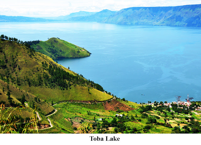
1. Danau Toba (Toba Lake)
Lake Toba is a tekto-volcanic lake with a length of 100 kilometers and 30 kilometers wide, located in North Sumatra Province, Indonesia. This lake is the largest lake in Indonesia and Southeast Asia. In the middle of this lake there is a volcanic island called Pulau Samosir.
Broad waters of Lake Toba is 1,130 km2 with a maximum depth of 529 meters. Flooded area by the lake Toba consists of 7 districts: Samosir, Toba Samosir, Simalungun, Tapanuli Utara, Humbang Hasundutan, Dairi and Karo. The position of Lake Toba is located in the northeast and extends to the south of the city of Medan. The nearest distance lake to the city of Medan is about 110 km.


2. Air Tejun Sipiso Piso (Sipiso Piso Waterfall)
Sipiso-piso is located not far from residential communities Tongging Village, Sub Brand, Karo District, of North Sumatra province. This waterfall has a height of 120 meters or about 360 feet before flowing into Lake Toba. Sipiso-piso is located not far from residential communities Tongging Village, Sub Brand, Karo District, of North Sumatra province. This waterfall is located in the southeast city of Medan at the distance of 100 km.


3, Pulau Samosir (Samosir Island)
Samosir Island is a volcanic island in the middle of Lake Toba in North Sumatra province. An island in the island with an altitude of 1,000 meters above sea level and has an area of 630 km2. On this island there are also two small lakes as a tourist area that Sidihoni Lake and Lake Aek Natonang who earned the nickname "lake on the lake".
Tuktuk are the centers of concentration of tourists on the island. From Parapat, Tuktuk can be connected to the ferry crossing. In addition to water transportation, Samosir Island can also be reached by road through Pangururan be a place where Samosir Island and Sumatra Island related.


4. PTPN IV Sidamanik (Sidamanik Tea Plantation)
PTPN Sidamanik also known as Bah Butong tea plantations. Bah Butong tea plantations located in the District Sidamanik, 26 km from Kota Pematangsiantar and is in the south of the city of Medan at a distance of 155 km from Headquarters in the city of Medan. Area of 2.684.84 Ha with a height = 890 masl. Clonal tea plant consists of Clonal Plants (Gambung Group).


5. Air Tejun Sigura Gura ( Sigura Gura Waterfall)
Sigura Gura is the highest waterfall in Indonesia sourced from Asahan river with a height of 250 m. In this place was built Lestrik Hydropower Plant. It lies to the south of the city of Medan with the distance of 239 km and included into the district of Toba Samosir.


6. Gunung Sibayak (Mt. Sibayak)
Mt. Sibayak (Indonesian:Gunung Sibayak) is a small stratovolcano overlooking the town of Berastagi in northern Sumatra, Indonesia. The mountain is often used as a place for mountaineers. Anyone can climb up to reach its peak. The mountain is often used as a place for mountaineers. Anyone can climb up to reach its peak. The mountain is Often used as a place for mountaineers. Anyone can climb up to reach its peak. The mountain is located in the south of Medan with the distance of 64 km.


7. Dolok Tinggi Raja (White Crater Tinggi Raja)
Dolok TInggi Raja is a nature reserve covering an area of 167 ha located in District Glare Kahen, Simalungun, North Sumatra province. In the area of the nature reserve mountain high king, there is attraction white crater, which is more commonly known as the white crater high king area of 30 hectares. [1] However, this makes the attraction crater high white king hard to grow, due to collide the status of this area located area of the Nature Reserve.


8. Pantai Sorake (Sorake Beach)
Sorake is a beach adjacent to the beach Lagundri. This beach is located in the district of Teluk Dalam, South Nias, North Sumatra. Sorake famous big waves so it is suitable for surfing. The beach is located on the island of Nias, an island which is opposite the west coast of mainland North Sumatra Province.


9. Danau Linting (Linting Lake)
Linting Lakes Region is located in the village of Sibunga-interest Hilir subdistrict Sinembah Tanjung Muda, Deli Serdang, North Sumatra. Linting lake is a volcanic lake with green water Tosca or bluish. At the edge of the lake is filled with trees. You have to be careful if you want to swim in the lake where the water contains sulfur Linting this. Because the depth of the lake is 100 meters. For visitor safety, on the edge of the lake has been given a fence. The lake is located south of Medan at the distance of about 54 km.


10. Air Terjun 2 Warna (Two Colors Waterfall)

Two Colors Waterfall had another name  Air Terjun Telaga Bitu Sibolangit is a stream of water falling from a height of 75 meters and is located 1475 meters above sea level (masl). Waterfall Two Colors Sibolangit quite unique because it consists of two waterfalls, the waterfall was blue and feels cold, the other one is white and the water is warm. Both waterfalls are separated by several small waterfalls and high cliffs are filled with moss. The place is located in the south of Medan with the distance of about 45 km 


11. Pantai Legundri (Legundri Beach)
Lagundri beach and Sorake beach are two beaches that are within the coastline. Distance to the beach it is only two kilometers. Lagundri beach and located in the village of Sorake Botohilitano, Teluk Dalam, South Nias, North Sumatra Province. Both beaches are already famous among domestic and foreign professional surfers. The lovers of surfing like this place because it folds wave height capable of achieving 7 to 10 meters with five levels. In addition, the length of the driving force of the waves in this area in fact can reach 200 meters. It would be interesting and challenging waves on arrival of the full moon. One made waves at this Lagundri is ideal for windsurfing because of its location facing the Indonesian Ocean and is also a meeting point for the bay so that the large waves will flow.


12. Pulau Mursala (Mursala Island)
Mursala is the largest island owned by Central Tapanuli. 8,000 hectares of the island is located approximately 22.5 km from Kota Sibolga and entered in the District Tapian Nauli, Central Tapanuli, North Sumatra Province. Mursala is surrounded by a beautiful stretch of sand. In addition, there is also a tourist attraction that is a mainstay in Mursala, namely Mursala Waterfall. Mursala Waterfall with a height of about 35 m waterfall is unique because the flow of the waterfall here straight into the sea. Because the location of this waterfall is in part Mursala dealing directly with the Indian Ocean waterfall flows directly into the sea.


13.  Danau Siombak (Siombak Lake)
Siombak Lake is an artificial lake with an area of approximately 40 hectares, diameter of about 1000 meters, and a depth of approximately 12 meters. The lake is located in the village of Paya Pasir, Marelan Medan, Medan, North Sumatra. Siombak lake situated between two rivers, namely Sungai Deli and River Falls. Lake water here greenish colored clear, because at the bottom of the lake overgrown with moss and algae type of plant, but the water is odorless. 


14. Pantai Natal (Natal Beach)
Natal beach, Natal subdistrict, Mandailing Natal (Madina). This beach is located on the west side of North Sumatra province and is located in the southern city of Medan with a mileage of 550 km. This beach can be said to be a virgin beach is very potential to be developed into a marine tourism area that is not less interesting to nautical tourism in other areas. 


15. Pantai Binasi (Binasi Beach)
Binasi beach located in District Sorkam West Central Tapanuli. The beach directly opposite the Indian Ocean is relatively gently sloping sand and have such long endless. The position of the beach is located in the west of North Sumatra Province. As far as the eye could see just looks white coastline until finally dropping behind trees. Until now BinasI Turkish tourist area just managed the local community. So that the existing facilities are still modest. This Beach from Pandan town has a distance of approximately 50 km or 40 km if from Sibolga to Barus direction.


16. Pulau Asu (Asu Island)
Asu Island is located in the District of Hinako Islands, Nias Barat, North Sumatra. Asu Island to the west of West Nias directly adjacent to the Indian Ocean and includes the outer islands of Nias Islands. The island of Asu approximately 18 square kilometers currently inhabited by 28 households.


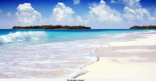
17.  Pulau Siroktabe (Siroktabe Island)
iroktabe Island is one of the islands located in North Sumatra. The island is completely uninhabited, there is no facility such as a place to stay or a meal or food stalls on the island Siroktabe, but, it's where the appeal. This island will feel like being a private island with a quiet and comfort ambiance traveler will find when visited. Exotic beach with wonderful beach sand and Siroktabe Island became one of the islands have marine life that is still awake. The island is included on Nias Island neighborhood.


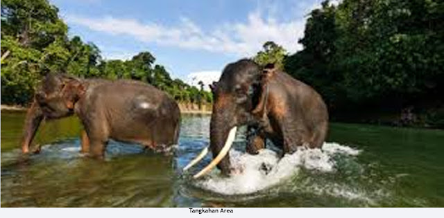
 18. Kawasan Tangkahan  (Tangkahan Area)
Tangkahan well-known as the hidden paradise of Gunung Leuser National Park, is an Eco Tourism area in the Langkat district of North Sumatra. The peaceful jungle retreat is located along the Kualsa Buluh River next to the dense rainforest, just 2.5 hours far from Bukit Lawang driving on a bumpy road through palm oil plantations and rural villages.
It is the perfect place to lay back from strong traveling and spend a memorable time with seven rehabilitated adult Sumatran elephants and a few small calves who work together with the rangers to patrol the rainforest


19.  Batu Gantung (Hanging Rock)
Hanging Rock is a natural form of rock carvings located in Parapat, North Sumatra. Geographically, Hanging Rock is located in the distance is not so far from the waters of Lake Toba. These rocks will make anyone stunned because its position is hanging from the rocks around the cliffs. This typical stone location is approximately 176 km from the city of Medan. 


20. Danau Lau Kawar (Lau Kawar Lake)
Lau Kawar Lake, is a lake that is located in the village of Kutagugung, District Naman Teran, under the foot of the volcano Sinabung, Karo District, North Sumatra Province. The lake has an area of 200 hectares has beautiful scenery around the lake in the form of green hills add fresh flavor and makes the water a greenish color 

Sunday, February 28, 2016

The Great 20 Beautiful Scenary from West Sumatra

West Sumatra lies in the middle of the western coast of Sumatra, and has an area of 42,130.82 km2 and its capital is Padang city . Geographic features include plains, mountainous volcanic highlands formed by the Barisan mountain range that runs from north-west to south-east, and an offshore island archipelago called the Mentawai Islands. The West Sumatran coastline faces the Indian Ocean and stretches 375 km from North Sumatra province in the north-west to Bengkulu in the south-east. 

Natural attractions of the mainland include the tropical forests, mountains, volcanos, lakes, valleys, rivers & waterfalls in the highlands, the fauna and flora, and the beaches around Padang. Many areas are protected as part of national parks and reserves. The city of Bukuttinggi is a popular central location in the highlands from which to explore the culture and history of the Minangkabau people, including architecture, crafts, dances, music and food. Some of the attractions of nature with beautiful scenery can be seen in the following places:

1. Ngarai Sianok (Sianok Valley)
Sianok Canyon is a steep valley (ravine) located in the border town of Bukittinggi, in the district of IV Koto, Agam, West Sumatra. The valley is elongated and meandering as the southern boundary of the city of Koto Gadang to Sianok Anam tribe villages, and ended up in the district Palupuh.
Sianok canyon is located in the city of Bukittinggi has a depth of about 100 m, stretches along 15 km with a width of about 200 m, and is part of the fault that separates the island of Sumatra in half lengthwise. This fault forms the walls are steep, even perpendicular and form a green valley-result of decreased movement of earth crust (sinklinal) -which flowing river water is clear Sianok.
Distance from Padang to this place is about 95 km.


2. Danau Singkarak (Singkarak Lake)
Lake Singkarak (Indonesian: Danau Singkarak) is a lake in West Sumatra, Indonesia. It is located between the cities of Padang Panjang and Solok. It has an area of 107.8 km², being approximately 21 km long and 7 km wide. . Lake Singkarak is located northeast of Padang at a distance of 78.1 km through the town of Solok.


3. Air Terjun Nyarai (Nyarai waterfall)
Nyarai located deep in forests Gamaran, Jorong Gamaran, Jorong Salibutan, District Lubuk Alung, Padang Pariaman, West Sumatra. To reach the location take 2 to 3 hours to visit the falls from the mouth of the forest on foot
The flow of water from the waterfall into the pool, at the weir by two rocks such as doors, like a dam that regulates the flow of water coming
into the pool. Nyarai watefals only has a height of about 7-8 meters, but the interesting part of this waterfall is a large pool , with a greenish colored water, the pool is right in front of the waterfall there are fish. Forests where the waterfall is located to the north of the city of Padang at a distance of about 42 km.


4. Lembah Harau (Harau Valley)
Harau Valley is a canyon near the town of Fifty Koto Payakumbuh district, West Sumatra province. Harau valley flanked by steep rocky hills with a height of 150 meters. Harau Valley .dilingkungi steep sandstone colorful, with a height of 100 to 500 meters. Harau Nature Reserve topography is hilly and undulating. Height from sea level is 500 to 850 meters, the hill include the Hill Air Putih, Bukit Jambu, Bukit Singkarak and Bukit Tarantang. Harau valley distance of from the city of Padang to this place is about 138 km to the northeast.


5 Sarasah (Sarasah Waterfall)
Padang has a very beautiful waterfall. The name of the waterfall is Sarasah. This waterfall is 17 km from the city center.  Sarasah Waterfall Ulu Gadut actually has seven levels and each level has its own path. Waterfall of this first stage will see the water flowing straight from a distance which is Niagara Sarasah Ulu Gadut second level.
To get to it fairly easy to climb the rocks of the waterfall first rate. Height of the waterfall is about 10-15 meters and has a pool. If you've arrived at the location, be careful because the rocks in the waterfall is slick and mossy. Visitors usually when it comes to Niagara Sarasah Gadut Ulu only until the first and second levels.


6. Lembah Anai (Anai Valley)
Anai Valley Nature Reserve is a protected forest area located in West Sumatra, the region has a dense tropical forest with various species of flora and fauna. Natural beauty and rare flora and fauna that is the appeal of the Anai Valley, the natural beauty of which there are three waterfalls and a lake where the water is bluish. One of the waterfalls are located on the side of the road, while the two of them are still covered by a dense grove of trees. Located in the path of Padang - Bukittinggi. From the city of Padang to this location within 67 km.


7. Bukit Langkisau (Langkisau Hill) 
Bukit Langkisau an elongated hills that lined the north side of town Painan. The hill is often used for hang gliding. Langkisau hill is located 82.3 km to the south of the city of Padang. 


8. Pulau Pemutusan (Pemutusan Island)
The island, located in the Bungus Teluk Kabung, with an area of 8 hectares Padang has white sand and plant palm trees and mangrove trees and hills are still green. Additionally, biota, fish and coral reefs are found in the sea around the island is also a main attraction for fans of snorkling Towards Pamutusan Island can be reached by small boats from the Port Muara Padang city about an hour's drive northwest. 


9. Danau Maninjau (Maninjau Lake)
Lake Maninjau (Indonesian: 'Danau Maninjau', meaning overlook or observation in the Minangkabau language) is a caldera lake in West Sumatra, Indonesia. It is located 36 km to the west of Bukittinggi.  Lake Maninjau has an area of 99.5 km², being approximately 16 km long and 7 km wide. The average depth is 105 m, with a maximum depth of 165 m. The natural outlet for excess water is the Antokan river, located on the west side of the lake. It is the only lake in Sumatra which has a natural outlet to the west coast. Since 1983 this water has been used to generate hydroelectric power for West Sumatra, generated around 68 MW at maximum load.
Most of the people who live around Lake Maninjau are ethnically Minangkabau. Villages on the shores of the lake include Maninjau and Bayur.


10. Kepulauan Mentawai (Mentawai Islands)
The Mentawai Islands are a chain of about seventy islands and islets off the western coast of Sumatra in Indonesia. Siberut at 4,030 square kilometres (1,556 square miles) is the largest of the islands. The other major islands are Sipora, North Pagai (Pagai Utara) and South Pagai (Pagai Selatan). The islands lie approximately 150 kilometres (93 miles) off the Sumatran coast, across the Mentawai Strait. The indigenous inhabitants of the islands are known as the Mentawai people. The Mentawai Islands have become a noted destination for surfing.


11. Danau Diatas Danau Dibawah (Twin Lakes)
Danau Diatas means Upper lake and Danau dibawah means Down lake is twin lake in West Sumatra, precisely located at Solok. The name of Twin Lakes is taken from the two lakes, Danau Atas and Danau Bawah that located side by side, which is only about 300 meters long. The first area is known as a tourist attraction because it is located on the edge of the highway Padang-Muaralabuh-Kerinci. Danau Diatas has 17.20 square meters, 6.25 km length and 2.75 km wide, the water surface is at an altitude of 1,600 meters above sea level. The lake is quite shallow, the deepest part is only 44 meters.
While the water level of Danau dibawah is in an altitude of 1,566 meters above sea level. That is, the surface of the water as high as the base on the water of Danau dibawah. However, the lake has an area of 16.90 square meters, of 5.62 km length and 3.00 km wide is very deep, which is 886 meters.


12. Pulau Siberut (Siberut Island)
Siberut island located in the Mentawai Islands have a very charming Panorama. The island has an area of 4.030 square kilometres. Because the island is located in the Indian Ocean make this Siberut Island has waves were quite ferocious in the southern part of the island, while in the northern part of the island has a fairly quiet waves.


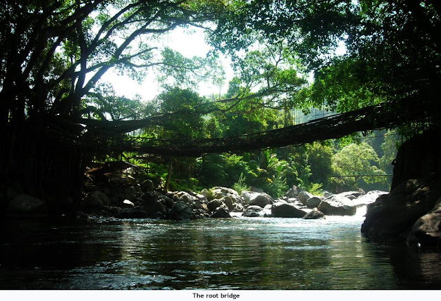
13. Jembatan Akar (The root bridge)
The root bridge is the bridge of the two roots of a tree whose roots are connected across the river into a bridge that can be passed to 10 people. This is an object mainstay of the South Coastal District, which is one of the most unique bridges. Located in the South Coastal District, West Sumatra and located in the South of Padang City with distance about 82 Kilometer


 14.  Pantai Bungus (Bungus Beach)
Bungus beach located in the bay of mourning. This beach is located 20 km south of Padang, or 1.5 hours of travel, the beach is easily accessible by land transportation. Shape resembles a crescent beaches. Sea water is warm and safe for swimming. From here, you can menjelejahi sea to the nearby beaches off the coast of Padang like Sirandah Island, Sikowi, Bintangur, Pasumpahan and other islands. 


15. Pantai Air Manis (Air Manis Beach)
Air Manis beach is located in District Kabung Bay district, Padang, West Sumatra, or within about fifteen kilometers from the center of Padang. In addition to having a beautiful view of the waves on the beach is not too high. The specialty of this beach is located on a stone which is associated with the legend of Malin Kundang located around the beach area. Not far from this beach there is a small island called Small Banana Island. The distance is only about 500 meters away from Batu Malin Kundang. To be able to Small Banana Island, visitors can rent a boat or also by foot. But keep in mind, when choosing a walk, then you should immediately return to Sweet Water Beach before 16:00 pm, because the sea water is usually already started to rise. 


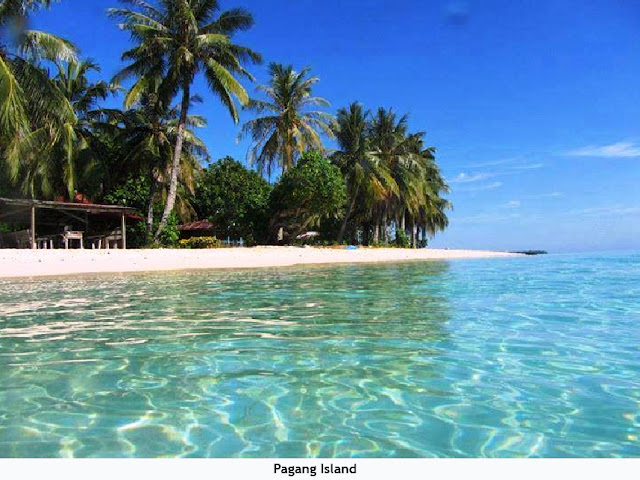
16. Pulau Pagang (Pagang Island)
Pagang Island, a small island part of the South Coastal District, West Sumatra. This 10-hectare island has white sandy beaches are soft and warm, waving palm trees dominate the small unspoiled forests. Surrounded by clear blue waters nan quiet and well-preserved coral reefs make the island their target hobbyist Pagang into snorkeling, or just want tasted the sensation of swimming in the open sea.


17. Pulau Pasumpahan (Pasumpahan Island)
Pasumpahan just a 1 hour drive from the coast in the city of Padang. Underwater tourism potential in the area of marine tourism west coast city of Padang is in the form of regional coral reef ecosystems found in almost every island, including the islands of Gosong. In addition to various types of coral reef fish or ornamental fish are also very attractive to be enjoyed by tourists. Sand along the beach with waves Pasumpahan which became the main attraction of this beach. 


18. Air Terjun Lembah Harau (Harau Waterfall)
Harau Waterfall located in the canyon Harau, Payakumbuh,  has a height of about 150 meters. Located 35 km from Bukittinggi on the sidelines of the hills Harau valley where there is a deep chasm and a very beautiful waterfall. At certain moments, waterfalls around Harau Canyon Payakumbuh sometimes met by a group of butterflies flying around, making the scenery around the waterfall has become very beautiful. 


19. Air Terjun Bayang Sani (Bayang Sani Waterfall)
Bayang Sani Waterfall is located in the village of Koto Baru subdistrict Bayang.Air.  This waterfall with a height of nearly 80 tens of meters is divided into three tiers waterfall of Batang Bayang Sani, who came from far upstream on the hill. This attraction is 60 km from the city of Padang and 20 km from the city Painan 


20. Telaga Dewi (Dewi Lake)
Telaga Dewi is a lake located on top of Mount Singgalang volcano, located in the city of Padang Panjang, West Sumatra at an altitude of 2877 meters above sea level. This lake is the crater of Mount Singgalang that is no longer active. The beauty of the lake has an area of more than two hectares is indeed enchanting