West Kalimantan is a province of Indonesia, located on the island of Borneo to the provincial capital Pontianak. The area of West Kalimantan Province is 146 807 km². West Kalimantan bordering land with the state of Sarawak, Malaysia. Although a small part of West Kalimantan is a marine, but the West Kalimantan has dozens of large and small islands (mostly uninhabited) are scattered throughout Karimata Strait and Natuna Sea bordering the province of Riau Islands. West Kalimantan province has many beautiful natural landscapes which are as follows :
1. Pantai Pulau Datok (Pulau Datok Beach)
Pulau Datok beach located in the National Park Mountain Trench, precisely in the Village Sutra, District Sukadana, District of North Kayong. Along this coast there are also many types of palm trees, acacia, Manggis forests, shady. On the afternoon of this place can look at the sunset. This Beach location adjacent to Mount Peramas.
2. Pulau Randayan (Randayan Island)
Randayan is an island located in the northern coastal areas of West Kalimantan Province. The island has a very beautiful nature, as well as the underwater scenery is very exotic. In addition, the white sand beaches owned Randayan Island is very beautiful and attractive. The scenic beauty of the underwater island is truly remarkable because Randayan Island has a beach and the sea water is very clear so it is suitable for sport diving.
To get to the island Randayan, you can through the Gulf of Suak. The journey from Pontianak to Suak Bay can be reached within 2.5 hours with a distance of 115 km. The bay is located in 32 km from Singkawang. From the Suak Bay can use speedboat.
3. Pantai Tanjuru (Tanjuru Beach)

4. Air Terjun Riam Berawan (Riam Berawan Waterfall)
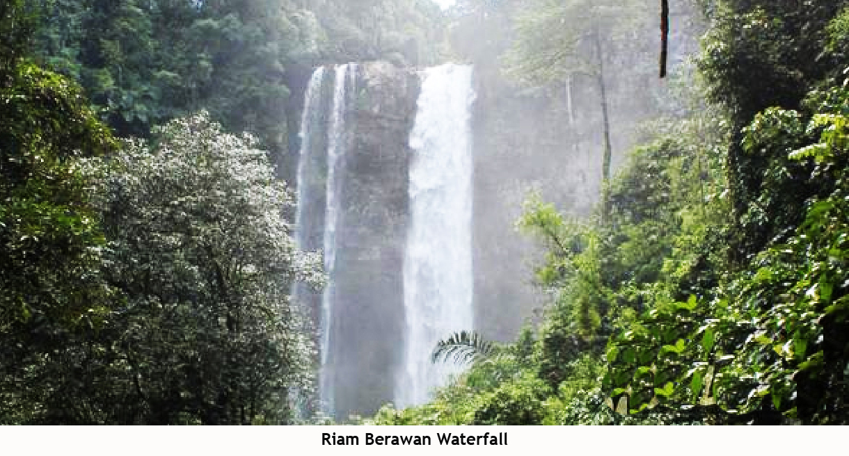
Riam Berawan waterfall is the highest waterfall in Bengkayang with a height of up to 75 m. The waterfall is located in the Village area Sahan, Hamlet Levitating, Seluas District, Bengkayang. Distance from city Bengkayang to a location about 76 Km. Riam Berawan waterfall have a total area of approximately 5 hectares,
5. Taman Nasional Betung Kerihun
(Betung Kerihun National Park)

Betung Kerihun National Park is a national park in the province of West Kalimantan on the island of Borneo, Indonesia. It is located inland, along the Malaysian border. The park was established in 1995 and has a total area of 8,000 km2 (3,100 sq mi) or about 5.5 percent of West Kalimantan Province area. Together with the 2,000 km2 (800 sq mi) Lanjak Entimau Wildlife Sanctuary in Malaysia, it has been proposed to form a World Heritage Site named the "transborder Rainforest Heritage of Borneo".Betung Kerihun National Park is Hilly and mountainous, with altitudes ranging from 150 m (490 ft) to almost 1,800 m (5,910 ft). The topography is Characterized by steep slopes, with more than half of the park area having slopes over 45%. The highest peaks are Mount Kerihun (1,790 m or 5.870 ft) and Mount Lawit (1,767 m or 5,800 ft). The park is located at the Headwaters of the Kapuas River.
6. Pantai Pasir Panjang (Pasir Panjang Beach)

Pasir Panjang is the natural attractions in the form of white sandy beaches and long, located in District Seventeen, Singkawang, West Kalimantan. This beach stretches along three kilometers, so-called Pasir Panjang. This beach has beautiful white sand and calm waves. This beach can be reached by driving for 20 minutes (17 km) from the center of Singkawang towards Pontianak. Sand beaches are broad and clean make this area comfortable to use for sunbathing or doing sports activities, such as beach volleyball and beach soccer.
7. Pantai Selimpai (Selimpai Beach)

Selimpai beach located on the island Selimpai Paloh which is one conservation area located in West Kalimantan with name Natural Park Tanjung Belimbing. This beach is located in the village of Sebubus, District Paloh, Sambas district (approximately 7 km from the capital district and 45 km north of the city of Sambas).
This beach is a cape or a part of its land juts into the sea, between the sea and the mouth of the river line distance is only as wide as a big field. The uniqueness you'll find in this section, you will see the shoreline overlooking the river and shoreline overlooking the sea and other parts.
This beach is a cape or a part of its land juts into the sea, between the sea and the mouth of the river line distance is only as wide as a big field. The uniqueness you'll find in this section, you will see the shoreline overlooking the river and shoreline overlooking the sea and other parts.
8. Air Terjun Nokanayan (Nokanayan Waterfall)

Nokanayan Waterfall located in Melawi river upstream, in the districts of Ambalau with the potential and attractiveness of beautiful natural scenery with waterfalls height of 180 meters. The location of this waterfall does not have road access so the journey must be taken to cascade down the river Melawi. To reach this location requires a two-day trip from Pontianak - West Kalimantan is one day use the road and one day using a speed boat through the river
9. Pantai Pulau Sawi (Sawi Island Beach)

Sawi Island Beach is a tourist attraction in the territory of the District Kendawangan Tengar River Village, a distance of approximately 80 km from the city of Ketapang. Besides the beautiful scenery, the place is also a place for turtle habitat. Various species of sea turtles such as the leatherback turtle, green turtle, hawksbill and Totong there are many in this area. Stretches of white sand, sparkling blue sea water. Very naturally then this island nicknamed Angel Island.
10. Pantai Tanjung Batu (Tanjung Batu Beach)

Tanjung Batu beach is a beach shaped headland, the natural form that consists of rocky hills and jutting into the sea to a height of approximately 80 meters. Tanjung Batu beach located 47 kilometers from the center of Sambas district. At the foot of the hill there is a lot of stones that extend to the sea which can be seen at low tide when the water in the state. Attractions Tanjung Batu is equipped with a mountain that serves as a natural fortress. There are so many rocks that enclose this beach area, therefore called Tanjung batu. This location there is a stretch of white sand, rocks jutting into the sea, rows of cypress trees along the roadside. In certain seasons there are many turtle eggs. some islands just off the coast of Tanjung Batu
 Sentarum Lake is a seasonal lake is one part of Sentarum National Park. The lake is located 700 km from Pontianak. The overall site area of Lake Sentarum 132,000 plus 64,000 hectares proposed as a buffer zone. About 20 hectares is a seasonal lake that became the cover an area of 30,500 hectares, the rest is deposited in the lake. Sentarum lake is a giant water storage reserves, for the rainy season, the water level in the lake is up to 14 meters. However, when the dry season comes, all you see is hundreds of fish ponds and a number of small rivers. Having Sentarum Lake is an advantage for West Kalimantan, because during the dry season, the lake supply half of the water flow through the Kapuas River.
 Pawan River is a river located on the Ketapang looks very wide and winding when viewed from above. The river is surrounded by dense forests, very similar to the Amazon jungle in Brazil. Pawan river itself connects the area Ketapang District of Sandai, Nanga Tayap and Sungai Laur. The view from the top Ketapang wilderness does look amazing.
In addition to wilderness, Ketapang also famous for its beach that extends from south to north. The beach can be met in Ketapang like Sungai Jawi Beach (Beach Penage), Tanjung Batu Beach, Fences Cucumber Beach, Air Mata Beach Permai, and Cape Coast belandang.
11. Danau Sentarum (Sentarum Lake)
 Sentarum Lake is a seasonal lake is one part of Sentarum National Park. The lake is located 700 km from Pontianak. The overall site area of Lake Sentarum 132,000 plus 64,000 hectares proposed as a buffer zone. About 20 hectares is a seasonal lake that became the cover an area of 30,500 hectares, the rest is deposited in the lake. Sentarum lake is a giant water storage reserves, for the rainy season, the water level in the lake is up to 14 meters. However, when the dry season comes, all you see is hundreds of fish ponds and a number of small rivers. Having Sentarum Lake is an advantage for West Kalimantan, because during the dry season, the lake supply half of the water flow through the Kapuas River.
12. Sungai Pawan (Pawan River)
 Pawan River is a river located on the Ketapang looks very wide and winding when viewed from above. The river is surrounded by dense forests, very similar to the Amazon jungle in Brazil. Pawan river itself connects the area Ketapang District of Sandai, Nanga Tayap and Sungai Laur. The view from the top Ketapang wilderness does look amazing.
In addition to wilderness, Ketapang also famous for its beach that extends from south to north. The beach can be met in Ketapang like Sungai Jawi Beach (Beach Penage), Tanjung Batu Beach, Fences Cucumber Beach, Air Mata Beach Permai, and Cape Coast belandang.
nc beach wallpaper!
ReplyDeleteyoutube movie downlaod now click here!!
see now funny video!!
earn money form online !!